
![]()
![]()
![]()
![]()
![]()
![]()
![]()
 |
||
| Internet Weather Info | ||
|
We have found access to the internet relatively easy everywhere we have been so far. Internet cafes are everywhere and wireless internet is usually available onboard in the marinas and (occasionally) out at anchor, however, most cruisers we met found that an aerial was required to benefit from this service.
The internet is a fantastic source of weather info and we have listed the links we tend to use frequently. |
|
|
|
NOAA |
||
|
Sourced from www.nws.noaa.gov/om/marine/home.htm Format: Charts & Text
Major American site - click here for surface charts up to 96 hr ahead for both West (10E-45W NW Atlantic) and East Atlantic (45W-85W NW Atlantic). Note: the same page gives useful wind wave forecasts and also satellite images for the whole North Atlantic -as given above.
Text forecasts and weather discussions are also available online. We use: Offshore waters forecast for the southwest and tropical North Atlantic & Caribbean Sea High seas forecast for MetArea IV |
||
|
WETTERZENTRALE |
||
|
Sourced from www.wetterzentrale.de Format: Charts
This is a German website and it covers up to five days ahead for all the major oceans of the world. From the top area of the linked page you need to select the oceanic area - currently Sud Amerika and then pick the number of hours forward that you wish to view. The graphic then provides wind and wave height predictions. |
||
|
UNYSIS ATLANTIC WEATHER 48HR
|
||
|
Sourced from www.unysis.com Format: Charts
This covers up to 48 hours ahead. It is similar to the German site referred to above but gives a slightly better feel for the location of the High and Low pressure areas. Also available are +00hr, +24hr and +36hr. This site also summarises 2005 and 2006 hurricane and tropical storm information. If you want to have a look back to previous years or other ocean areas click here. |
||
| US NAVY |
||
|
Sourced from www.fnmoc.navy.mil Format: Charts
The US Navy has a wealth of information available to the public. The following links are particularly appropriate: wave/wind forecasts and wind forecasts. |
||
| WEATHER ONLINE UK |
||
|
Sourced from www.weatheronline.co.uk Format: Charts
This site contains lots of useful information including key Trade Winds areas in the Atlantic for several days ahead. Also provides options for sea temperatures and satellite picture.
For the Eastern Caribbean region click here. |
||
|
METEO FRANCE - ATLANTIC |
||
|
Sourced from www.meteofrance.com Format: Charts
Covers about 36 hours. You may need Broadband to benefit fully from the available animations. The main link goes directly to synoptics (frontes) but you can then also select winds (ventes) and from there get wave heights (vagues). |
||
|
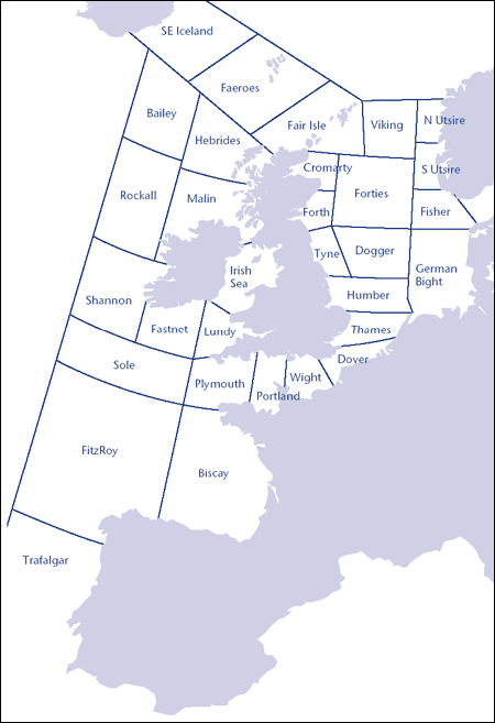
THE SHIPPING FORECAST 24HR |
||
|
Sourced from http://www.metoffice.gov.uk/weather/marine/ Format: Text
Broadcasted on Radio 4 LW every day at the following times (UK time): 0048 0520 1200 1755
It is also possible to receive the shipping forecast by email.
Forecast is for 0-24hours. Covers the British Isles to Northern Spain.
For information on the areas covered click on the image opposite. |
 |
|
|
MET OFFICE INSHORE FORECAST 48HR |
||
|
Sourced from www.meto.gov.uk Format: Text
For UK coastal cruising only. |
||
|
SYNOPTIC CHARTS |
||
|
Sourced from www.metcheck.com and www.metoffice.com Format: Charts
These charts cover Western Europe very well and give forecasts up to five days ahead. Alternatively follow an animated version at Met Office - broadband recommended. John had slight troubles with this site getting the charts so his trick is press the link go to the site, click the back button then click the forward button. |
||